
Mapa topográfico Davidson Lake
Mapa interactivo
Haga clic en el mapa para ver la altitud.
Acerca de este mapa
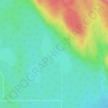
Nombre: Mapa topográfico Davidson Lake, altitud, relieve.
Altitud media: 292 m
Altitud mínima: 259 m
Altitud máxima: 369 m
Otros mapas topográficos
Haga clic en un mapa para ver su topografía, su altitud y su relieve.
Stoney Creek
Canada > Ontario > Thunder Bay District > Unorganized Thunder Bay District
Stoney Creek, Unorganized Thunder Bay District, Thunder Bay District, Northwestern Ontario, Ontario, Canada
Altitud media: 367 m
Ombabika River
Canada > Ontario > Thunder Bay District > Unorganized Thunder Bay District
Ombabika River, Unorganized Thunder Bay District, Thunder Bay District, Northwestern Ontario, Ontario, Canada
Altitud media: 311 m
Ara Lake
Canada > Ontario > Thunder Bay District > Unorganized Thunder Bay District
Ara Lake, Unorganized Thunder Bay District, Thunder Bay District, Northwestern Ontario, Ontario, Canada
Altitud media: 308 m
Ara Island
Canada > Ontario > Thunder Bay District > Unorganized Thunder Bay District
Ara Island, Unorganized Thunder Bay District, Thunder Bay District, Northwestern Ontario, Ontario, Canada
Altitud media: 305 m
Mowe Lake
Canada > Ontario > Thunder Bay District > Unorganized Thunder Bay District
Mowe Lake, Unorganized Thunder Bay District, Thunder Bay District, Northwestern Ontario, Ontario, Canada
Altitud media: 463 m
Pringle
Canada > Ontario > Thunder Bay District > Unorganized Thunder Bay District
Pringle, Unorganized Thunder Bay District, Thunder Bay District, Northwestern Ontario, Ontario, Canada
Altitud media: 289 m