
Mapa topográfico Cerro de Punta
Mapa interactivo
Haga clic en el mapa para ver la altitud.
Acerca de este mapa
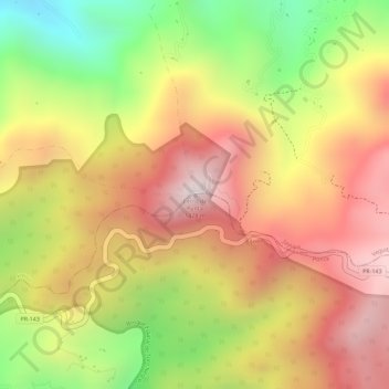
Nombre: Mapa topográfico Cerro de Punta, altitud, relieve.
Lugar: Cerro de Punta, Ponce, Puerto Rico, 00654, United States (18.17218 -66.59177 18.17228 -66.59167)
Altitud media: 1.021 m
Altitud mínima: 623 m
Altitud máxima: 1.309 m
The mountain is part of the Cordillera Central and is located on the border between the municipalities of Jayuya and Ponce. The access road to the point closest to the highest elevation is from the municipality of Jayuya. It is part of the Toro Negro Forest Reserve, and it has been described as "an alpine runt." It is located on the western end of the Toro Negro State Park. The mountain is just north of east-to-westbound Route 143. It is located at coordinates 18.172458 and -66.591839W. The nearest populated place to Cerro de Punta is Urbanización Vega Linda, located 3.3 miles (5.3 km) away.
Otros mapas topográficos
Haga clic en un mapa para ver su topografía, su altitud y su relieve.
Maragüez
United States > Puerto Rico > Ponce
Maragüez, Ponce, Puerto Rico, United States
Altitud media: 322 m