
Mapa topográfico Karer See - Lago di Carezza
Mapa interactivo
Haga clic en el mapa para ver la altitud.
Acerca de este mapa
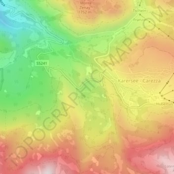
Nombre: Mapa topográfico Karer See - Lago di Carezza, altitud, relieve.
Altitud media: 1.606 m
Altitud mínima: 1.223 m
Altitud máxima: 1.950 m
The lake is located in the western Dolomites on the edge of the Latemarwald, just 20 kilometers southeast of Bolzano at 1520 m altitude in the municipality Welschnofen. The nearest settlement is Carezza. The roughly 300 m long and 140 m wide stretch of water is fed by underground springs from the Latemar mountain range.