
Mapa topográfico Leadgate
Haga clic en el mapa para ver la altitud.
Acerca de este mapa
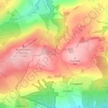
Nombre: Mapa topográfico Leadgate, altitud, relieve.
Altitud media: 183 m
Altitud mínima: 80 m
Altitud máxima: 261 m
Otros mapas topográficos
Haga clic en un mapa para ver su topografía, su altitud y su relieve.
Berwick-upon-Tweed
United Kingdom > England > Northumberland
In the 1840s, Samuel Lewis included similar entries for Berwick-upon-Tweed in both his England and Scotland Topographical Dictionary. Berwick remained a county in its own right, and remained a separate parliamentary constituency until 1885 when it was merged to become a division of Northumberland under the…
Altitud media: 33 m
North Hazelrigg
United Kingdom > England > Northumberland > Chatton > North Hazelrigg
Altitud media: 99 m
Catcleugh Reservoir
United Kingdom > England > Northumberland
Catcleugh Reservoir is a reservoir in Northumberland, England, adjacent to the A68 road just north of Byrness and to the southeast of the border with Scotland. It has a surface area of 98.654 ha and a mean depth of 9.8 m, a catchment area of 4007.5 ha, and is situated at 247 m altitude.
Altitud media: 316 m