
Mapa topográfico Kisumu
Mapa interactivo
Haga clic en el mapa para ver la altitud.
Acerca de este mapa
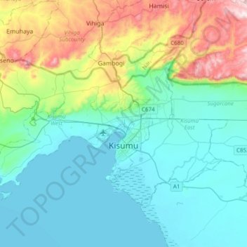
Nombre: Mapa topográfico Kisumu, altitud, relieve.
Lugar: Kisumu, City of Kisumu, Kisumu County, Nyanza, 40100, Kenya (-0.17522 34.57992 0.02263 34.88231)
Altitud media: 1.310 m
Altitud mínima: 1.131 m
Altitud máxima: 1.930 m
Its elevation is 1,131 m (3,711 ft) above sea level. Kisumu is about 320 km (200 mi) northwest of Nairobi and is located on the shores of Lake Victoria. It lies at the northeastern edge of the Winam Gulf, a long, shallow arm that protrudes from the main body of Lake Victoria. Kisumu is 24 km (15 mi) south of the equator and has, due to its elevation, moderate temperatures.
Otros mapas topográficos
Haga clic en un mapa para ver su topografía, su altitud y su relieve.
Andingo Bware
Kenya > Kisumu County > Nyakach > South West Nyakach ward
Andingo Bware, South West Nyakach ward, Nyakach, Kisumu County, Kenya
Altitud media: 1.431 m
Ainopngtuny/samjut Harji
Ainopngtuny/samjut Harji, Kisumu County, Nyanza, Kenya
Altitud media: 1.239 m
Kajulu Rakwaro
Kenya > Kisumu County > Kajulu Rakwaro
Kajulu Rakwaro, Kisumu County, Nyanza, Kenya
Altitud media: 1.143 m
Maseno
Kenya > Kisumu County > Kisumu West
Maseno, Kisumu West, Kisumu County, Nyanza, Kenya
Altitud media: 1.533 m