
Mapa topográfico Bassett
Mapa interactivo
Haga clic en el mapa para ver la altitud.
Acerca de este mapa
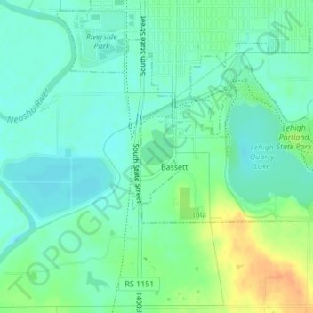
Nombre: Mapa topográfico Bassett, altitud, relieve.
Lugar: Bassett, Allen County, Kansas, United States (37.90126 -95.41019 37.91051 -95.40395)
Altitud media: 294 m
Altitud mínima: 282 m
Altitud máxima: 320 m
Otros mapas topográficos
Haga clic en un mapa para ver su topografía, su altitud y su relieve.
Humboldt
United States > Kansas > Allen County
Humboldt, Allen County, Kansas, United States
Altitud media: 293 m
Elsmore
United States > Kansas > Allen County
Elsmore, Allen County, Kansas, United States
Altitud media: 322 m
Gas
United States > Kansas > Allen County
Gas, Allen County, Kansas, 66742, United States
Altitud media: 310 m
Savonburg
United States > Kansas > Allen County
Savonburg, Allen County, Kansas, United States
Altitud media: 318 m
Moran
United States > Kansas > Allen County
Moran, Allen County, Kansas, United States
Altitud media: 334 m
Iola
United States > Kansas > Allen County
Iola, Allen County, Kansas, 66749, United States
Altitud media: 296 m
La Harpe
United States > Kansas > Allen County
La Harpe, Allen County, Kansas, 66751, United States
Altitud media: 313 m