
Mapa topográfico Steinhagen
Mapa interactivo
Haga clic en el mapa para ver la altitud.
Acerca de este mapa
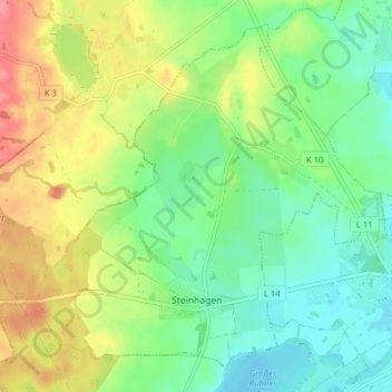
Nombre: Mapa topográfico Steinhagen, altitud, relieve.
Altitud media: 30 m
Altitud mínima: 0 m
Altitud máxima: 78 m
Otros mapas topográficos
Haga clic en un mapa para ver su topografía, su altitud y su relieve.
Teterow
Duitsland > Mecklenburg-Voor-Pommeren > Landkreis Rostock
Teterow, Landkreis Rostock, Mecklenburg-Voor-Pommeren, 17166, Duitsland
Altitud media: 39 m
Bad Doberan
Duitsland > Mecklenburg-Voor-Pommeren > Landkreis Rostock
Bad Doberan, Landkreis Rostock, Mecklenburg-Voor-Pommeren, 18209, Duitsland
Altitud media: 24 m
Dudinghausen
Duitsland > Mecklenburg-Voor-Pommeren > Landkreis Rostock > Hohen Sprenz
Dudinghausen, Hohen Sprenz, Laage, Landkreis Rostock, Mecklenburg-Voor-Pommeren, Duitsland
Altitud media: 34 m
Gorow
Duitsland > Mecklenburg-Voor-Pommeren > Landkreis Rostock > Satow
Gorow, Satow, Landkreis Rostock, Mecklenburg-Voor-Pommeren, 18239, Duitsland
Altitud media: 55 m
Werle
Duitsland > Mecklenburg-Voor-Pommeren > Landkreis Rostock > Kassow > Werle
Werle, Kassow, Schwaan, Landkreis Rostock, Mecklenburg-Voor-Pommeren, 18258, Duitsland
Altitud media: 23 m