
Mapa topográfico Nettleton
Haga clic en el mapa para ver la altitud.
Acerca de este mapa
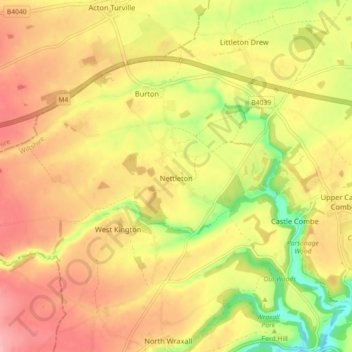
Nombre: Mapa topográfico Nettleton, altitud, relieve.
Lugar: Nettleton, Wiltshire, England, United Kingdom (51.47815 -2.32433 51.52207 -2.23431)
Altitud media: 128 m
Altitud mínima: 62 m
Altitud máxima: 175 m
Otros mapas topográficos
Haga clic en un mapa para ver su topografía, su altitud y su relieve.
Cley Hill
United Kingdom > England > Wiltshire
Cley Hill (grid reference ST838449) is a prominent hill to the west of Warminster in Wiltshire, England. Its summit has a commanding view of the Wiltshire / Somerset county boundary, at 244 metres (801 ft) elevation. The land is in Corsley parish and is owned by the National Trust.
Altitud media: 157 m