
Mapa topográfico Kisangani
Mapa interactivo
Haga clic en el mapa para ver la altitud.
Acerca de este mapa
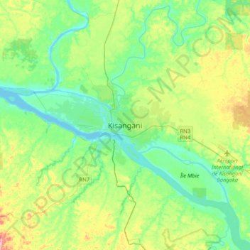
Nombre: Mapa topográfico Kisangani, altitud, relieve.
Lugar: Kisangani, Tshopo, Democratic Republic of the Congo (0.35840 25.04573 0.67840 25.36573)
Altitud media: 415 m
Altitud mínima: 378 m
Altitud máxima: 503 m
L'Île Mbiye is situated on the Congo River in the eastern part of Kisangani. It is located upstream of the Wagenia Falls, between latitude 0°31' North and longitude 25°11' East, with 376 metres (1,234 ft) of altitude. It adjoins the town of Kisangani, and it is 14 km long and 4 km wide. All around Kisangani, L'Île Mbiye is the only ecosystem that has a dense forest that is relatively well preserved. The island is part of the Sustainable Forest Management in Africa Symposium project of forest ecosystem conservation conducted by Stellenbosch University. The island has an area of 1,400 ha, and it comprises three types of forest: dry land forest, periodically flooded forest and swampy forest.
Otros mapas topográficos
Haga clic en un mapa para ver su topografía, su altitud y su relieve.
Isangi
Democratic Republic of the Congo > Tshopo > Isangi
Isangi, Orientale, Tshopo, Democratic Republic of the Congo
Altitud media: 371 m
Ubundu
Democratic Republic of the Congo > Tshopo > Ubundu
Ubundu, Orientale, Tshopo, Democratic Republic of the Congo
Altitud media: 433 m
Ikela II
Democratic Republic of the Congo > Tshopo > Ikela II
Ikela II, Orientale, Tshopo, Democratic Republic of the Congo
Altitud media: 559 m