
Mapa topográfico Oberwiesenthal
Mapa interactivo
Haga clic en el mapa para ver la altitud.
Acerca de este mapa
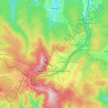
Nombre: Mapa topográfico Oberwiesenthal, altitud, relieve.
Lugar: Oberwiesenthal, Erzgebirgskreis, Saxony, 09484, Germany (50.40402 12.85948 50.46706 13.02269)
Altitud media: 928 m
Altitud mínima: 677 m
Altitud máxima: 1.249 m
Oberwiesenthal lies in the county of Erzgebirgskreis, on the border with the Czech Republic that follows the course of the Pöhlbach stream as far as Bärenstein (10 km northeast). The highest elevation in the borough is the Fichtelberg (sometimes called the Großer Fichtelberg or Great Fichtelberg) which, at 1,215 m above NN, is the highest mountain in Saxony.
Otros mapas topográficos
Haga clic en un mapa para ver su topografía, su altitud y su relieve.
08289
Germany > Saxony > Erzgebirgskreis > Schneeberg
08289, Griesbach, Schneeberg, Erzgebirgskreis, Saxony, Germany
Altitud media: 505 m
Ehrenfriedersdorf
Germany > Saxony > Erzgebirgskreis
Ehrenfriedersdorf, Erzgebirgskreis, Saxony, 09427, Germany
Altitud media: 582 m
Tannenberg
Germany > Saxony > Erzgebirgskreis
Tannenberg, Verwaltungsgemeinschaft Geyer, Erzgebirgskreis, Saxony, Germany
Altitud media: 590 m
Aue
Germany > Saxony > Erzgebirgskreis
Aue, Aue-Bad Schlema, Erzgebirgskreis, Saxony, 08280, Germany
Altitud media: 465 m
Olbernhau
Germany > Saxony > Erzgebirgskreis
Olbernhau, Erzgebirgskreis, Saxony, 09526, Germany
Altitud media: 612 m
Niederdorf
Germany > Saxony > Erzgebirgskreis
Niederdorf, Stollberg/Erzgeb., Erzgebirgskreis, Saxony, Germany
Altitud media: 413 m
Kühnhaide
Germany > Saxony > Erzgebirgskreis > Marienberg > Kühnhaide
Kühnhaide, Marienberg, Erzgebirgskreis, Saxony, 09496, Germany
Altitud media: 760 m
Andreasberg
Germany > Saxony > Erzgebirgskreis > Auerbach
Andreasberg, Auerbach, Burkhardtsdorf, Erzgebirgskreis, Saxony, 09390, Germany
Altitud media: 546 m