
Mapa topográfico Upper Lake
Mapa interactivo
Haga clic en el mapa para ver la altitud.
Upper Lake
Upper Lake is a census-designated place (CDP) in Lake County, California, United States. Upper Lake is located 8 miles (13 km) north of Lakeport, at an elevation of 1,345 feet (410 m). The population was 1,052 at the 2010 census, up from 989 at the 2000 census. The Habematolel Pomo of Upper Lake are headquartered here.
Acerca de este mapa
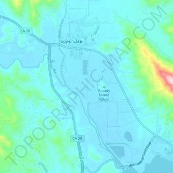
Nombre: Mapa topográfico Upper Lake, altitud, relieve.
Lugar: Upper Lake, Lake County, California, United States (39.11627 -122.92087 39.17969 -122.87066)
Altitud media: 440 m
Altitud mínima: 399 m
Altitud máxima: 782 m