
Mapa topográfico Valdivia
Mapa interactivo
Haga clic en el mapa para ver la altitud.
Acerca de este mapa
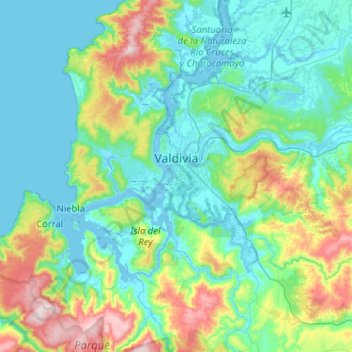
Nombre: Mapa topográfico Valdivia, altitud, relieve.
Lugar: Valdivia, Provincia de Valdivia, Los Ríos Region, Chile (-40.03202 -73.41394 -39.63708 -72.92085)
Altitud media: 143 m
Altitud mínima: -3 m
Altitud máxima: 705 m
Within the context of plate tectonics the city lies at a convergent margin where Nazca Plate in the Pacific is subducted beneath the South American Plate. Topographically Valdivia lies in a depression amidst the Chilean Coast Range. The basement rocks that crops out in the hills around the city are of metamorphic type. The city itself is chiefly built upon terraces made up of hardened volcanic sand. This volcanic sandstone is known as "cancagua" and deposited during the late Pleistocene epoch. As terraces took shape during the interglacial preceding the Llanquihue glaciation —the last glacial period— this interglacial is known in Chile as the Valdivia interglacial.
Otros mapas topográficos
Haga clic en un mapa para ver su topografía, su altitud y su relieve.
Neltume
Chile > Los Ríos Region > Provincia de Valdivia
Neltume, Panguipulli, Provincia de Valdivia, Los Ríos Region, Chile
Altitud media: 658 m
Villa California
Chile > Los Ríos Region > Provincia de Valdivia > Valdivia
Villa California, Valdivia, Provincia de Valdivia, Los Ríos Region, 5100861, Chile
Altitud media: 27 m
Villa Endesa
Chile > Los Ríos Region > Provincia de Valdivia > Valdivia
Villa Endesa, Valdivia, Provincia de Valdivia, Los Ríos Region, 5110244, Chile
Altitud media: 8 m