
Mapa topográfico North Cowichan
Mapa interactivo
Haga clic en el mapa para ver la altitud.
Acerca de este mapa
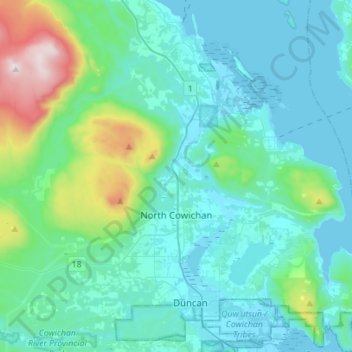
Nombre: Mapa topográfico North Cowichan, altitud, relieve.
Altitud media: 180 m
Altitud mínima: -1 m
Altitud máxima: 1.186 m
Otros mapas topográficos
Haga clic en un mapa para ver su topografía, su altitud y su relieve.
Cowichan River
Canada > Colombie-Britannique > Cowichan Valley Regional District > Area F (Cowichan Lake South / Skutz Falls)
Cowichan River, Area F (Cowichan Lake South / Skutz Falls), Cowichan Valley Regional District, Colombie-Britannique, Canada
Altitud media: 196 m