
Mapa topográfico Annette Island
Mapa interactivo
Haga clic en el mapa para ver la altitud.
Acerca de este mapa
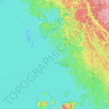
Nombre: Mapa topográfico Annette Island, altitud, relieve.
Altitud media: 198 m
Altitud mínima: 172 m
Altitud máxima: 324 m
Otros mapas topográficos
Haga clic en un mapa para ver su topografía, su altitud y su relieve.
St. Davids Island
Canada > Ontario > The Archipelago
St. Davids Island, The Archipelago, Parry Sound District, Ontario, Canada
Altitud media: 191 m
Isle of Bute
Canada > Ontario > The Archipelago
Isle of Bute, The Archipelago, Parry Sound District, Ontario, Canada
Altitud media: 198 m
Range Island
Canada > Ontario > The Archipelago
Range Island, The Archipelago, Parry Sound District, Ontario, Canada
Altitud media: 196 m
St. Helens Island
Canada > Ontario > The Archipelago
St. Helens Island, The Archipelago, Parry Sound District, Ontario, Canada
Altitud media: 189 m