
Gracias por apoyar a este sitio ❤️
Haz una donación
Haz una donación
Mapa topográfico Altenoythe
Haga clic en el mapa para ver la altitud.
Gracias por apoyar a este sitio ❤️
Haz una donación
Haz una donación
Altenoythe
Ahrensdorf | Altenoythe | Augustendorf | Edewechterdamm | Ellerbrock | Friesoythe | Gehlenberg | Heinfelde | Kampe | Kamperfehn | Markhausen | Mehrenkamp | Neuscharrel | Neuvrees | Pehmertange | Schlingshöhe | Schwaneburg | Schwaneburgermoor | Thüle
Gracias por apoyar a este sitio ❤️
Haz una donación
Haz una donación
Acerca de este mapa
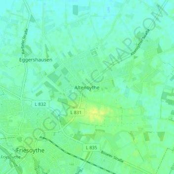
Nombre: Mapa topográfico Altenoythe, altitud, relieve.
Altitud media: 9 m
Altitud mínima: 3 m
Altitud máxima: 20 m
Gracias por apoyar a este sitio ❤️
Haz una donación
Haz una donación