
Haz una donación
Mapa topográfico Amravati
Haga clic en el mapa para ver la altitud.
Haz una donación
Amravati
Amravati is located at 20°56′N 77°45′E / 20.93°N 77.75°E / 20.93; 77.75. It has an average elevation of 343 meters (1125 feet). It lies 156 km (97 mi) west of Nagpur and serves as the administrative centre of Amravati District and of Amravati Division. The city is located near the passes through the hills that separate the cotton-growing regions of the Purna basin to the West and the Wardha basin to the East. Chikhaldara is about 80 km from Amravati city which is the only hill station in the Vidarbha region. The land area of the city is around 50.5 km2 (19.5 sq mi).
Haz una donación
Acerca de este mapa
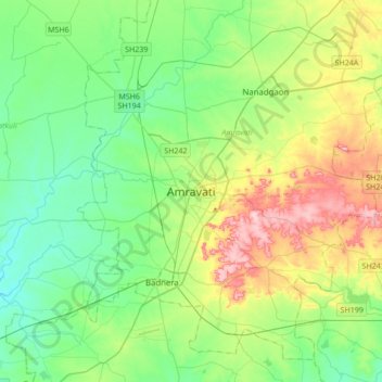
Nombre: Mapa topográfico Amravati, altitud, relieve.
Lugar: Amravati, Amravati District, Maharashtra, 444600, India (20.77162 77.59885 21.09162 77.91885)
Altitud media: 345 m
Altitud mínima: 287 m
Altitud máxima: 478 m
Haz una donación
Otros mapas topográficos
Haga clic en un mapa para ver su topografía, su altitud y su relieve.
Haz una donación
Haz una donación