
Mapa topográfico Emory Peak
Mapa interactivo
Haga clic en el mapa para ver la altitud.
Acerca de este mapa
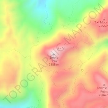
Nombre: Mapa topográfico Emory Peak, altitud, relieve.
Lugar: Emory Peak, Brewster County, Texas, United States (29.24585 -103.30515 29.24595 -103.30505)
Altitud media: 2.061 m
Altitud mínima: 1.694 m
Altitud máxima: 2.367 m
The peak can be reached by a moderate hike on a well-marked path across steep rocky terrain with an elevation gain of approximately 2,500 feet (760 m). The Emory Peak Trail is about 1.5 miles (2.4 km) long. The trail is reached by climbing the Pinnacles Trail 3.5 miles (5.6 km) from the Chisos Basin trailhead. Once at the base there is a semi-technical rock scramble to navigate before reaching the summit. No gear is needed for this climb although hikers should take great care. High-desert flora and fauna including alligator juniper (Juniperus deppeana), pinyon pine (Pinus cembroides), mule deer (Odocoileus hemionus), prickly pear cacti (Opuntia spp.), Mexican jay (Aphelocoma wollweberi), sotol (Dasylirion leiophyllum), and Texas madrone (Arbutus xalapensis) may be seen along the trail. There are signs warning of mountain lions and bears.
Otros mapas topográficos
Haga clic en un mapa para ver su topografía, su altitud y su relieve.
Alpine
United States > Texas > Brewster County
Alpine, Brewster County, Texas, United States
Altitud media: 1.373 m
Terlingua
United States > Texas > Brewster County
Terlingua, Brewster County, Texas, United States
Altitud media: 872 m
Alpine
United States > Texas > Brewster County
Alpine, Brewster County, Texas, United States
Altitud media: 1.373 m
Big Bend National Park
United States > Texas > Brewster County
Big Bend National Park, Brewster County, Texas, 79834, United States
Altitud media: 934 m
Big Bend National Park
United States > Texas > Brewster County
Big Bend National Park, Brewster County, Texas, 79834, United States
Altitud media: 934 m
Horseshoe Mesa
United States > Texas > Brewster County
Horseshoe Mesa, Brewster County, Texas, United States
Altitud media: 1.010 m
Marathon
United States > Texas > Brewster County
Marathon, Brewster County, Texas, 79842, United States
Altitud media: 1.244 m
Cathedral Mountain
United States > Texas > Brewster County
Cathedral Mountain, Brewster County, Texas, United States
Altitud media: 1.627 m
Santiago Peak
United States > Texas > Brewster County
Santiago Peak, Brewster County, Texas, United States
Altitud media: 1.525 m
Dagger Mountain
United States > Texas > Brewster County
Dagger Mountain, Brewster County, Texas, United States
Altitud media: 1.068 m
Lajitas
United States > Texas > Brewster County
Lajitas, Brewster County, Texas, United States
Altitud media: 755 m