
Mapa topográfico Town of Shelburne
Mapa interactivo
Haga clic en el mapa para ver la altitud.
Acerca de este mapa
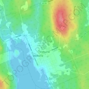
Nombre: Mapa topográfico Town of Shelburne, altitud, relieve.
Lugar: Town of Shelburne, Shelburne County, Nova Scotia, Canada (43.74952 -65.34439 43.78805 -65.29645)
Altitud media: 28 m
Altitud mínima: -1 m
Altitud máxima: 91 m
Otros mapas topográficos
Haga clic en un mapa para ver su topografía, su altitud y su relieve.
Town of Clark's Harbour
Canada > Nova Scotia > Shelburne County
Town of Clark's Harbour, Shelburne County, Nova Scotia, Canada
Altitud media: 2 m
Stoney Island
Canada > Nova Scotia > Shelburne County
Stoney Island, Municipality of the District of Barrington, Shelburne County, Nova Scotia, B0W 1P0, Canada
Altitud media: 3 m
Canada Hill
Canada > Nova Scotia > Shelburne County > Canada Hill
Canada Hill, Municipality of the District of Shelburne, Shelburne County, Nova Scotia, B0T 1L0, Canada
Altitud media: 34 m
Churchover
Canada > Nova Scotia > Shelburne County
Churchover, Municipality of the District of Shelburne, Shelburne County, Nova Scotia, B0T 1W0, Canada
Altitud media: 27 m
Ingomar
Canada > Nova Scotia > Shelburne County
Ingomar, Municipality of the District of Shelburne, Shelburne County, Nova Scotia, B0T 1W0, Canada
Altitud media: 5 m
Shelburne
Canada > Nova Scotia > Shelburne County > Shelburne
Shelburne, Town of Shelburne, Shelburne County, Nova Scotia, Canada
Altitud media: 28 m