
Mapa topográfico Los Alamos
Mapa interactivo
Haga clic en el mapa para ver la altitud.
Acerca de este mapa
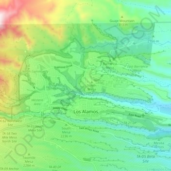
Nombre: Mapa topográfico Los Alamos, altitud, relieve.
Altitud media: 2.196 m
Altitud mínima: 1.990 m
Altitud máxima: 2.638 m
Los Alamos is located in northern New Mexico between the Rio Grande and the eastern rim of the Valles Caldera on the Pajarito Plateau, approximately 35 mi (56 km) to the northwest of Santa Fe. The elevation at the post office is 7,320 feet (2,230 m) and total land area is 11.14 square miles (28.9 km2).
Otros mapas topográficos
Haga clic en un mapa para ver su topografía, su altitud y su relieve.
Los Alamos
United States > New Mexico > Los Alamos County > Los Alamos
Los Alamos, Los Alamos County, New Mexico, 87544, United States
Altitud media: 2.196 m