
Mapa topográfico Arkhyz
Mapa interactivo
Haga clic en el mapa para ver la altitud.
Acerca de este mapa
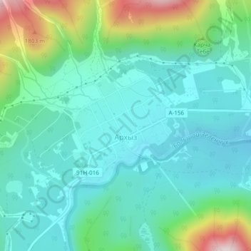
Nombre: Mapa topográfico Arkhyz, altitud, relieve.
Altitud media: 1.547 m
Altitud mínima: 1.427 m
Altitud máxima: 1.937 m
Arkhyz (also Nizhny Arkhyz Russian: Архыз; Karachay-Balkar: Ырхыз, Irxız; "mudflows") is a village in the valley of the Bolshoy Zelenchuk River, in the Republic of Karachay–Cherkessia, Greater Caucasus, Russia, about 70 km inland from the Black Sea shore. The modern village was founded in 1923 near the confluence of the Arkhyz and Pshish rivers. It is located in a mountainous region in the vicinity of the eponymous aul sitting at an altitude of 1,450 meters. The elevation of the surrounding mountains is more than 3,000 meters above the sea. The population is 505 (2010 Census).
Otros mapas topográficos
Haga clic en un mapa para ver su topografía, su altitud y su relieve.
Архыз
Russia > Karachay-Cherkessia > Zelenchuksky District
Архыз, Архызское сельское поселение, Zelenchuksky District, Karachay-Cherkessia, North Caucasian Federal District, Russia
Altitud media: 2.345 m