
Mapa topográfico Tepic
Mapa interactivo
Haga clic en el mapa para ver la altitud.
Acerca de este mapa
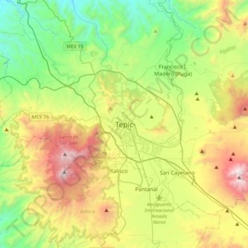
Nombre: Mapa topográfico Tepic, altitud, relieve.
Lugar: Tepic, Municipio de Tepic, Nayarit, 63009, Mexico (21.34434 -105.05468 21.66434 -104.73468)
Altitud media: 927 m
Altitud mínima: 185 m
Altitud máxima: 2.309 m
Located in the central part of the state, it stands at an altitude of 915 metres (3,002 ft) above sea level, on the banks of the Río Mololoa and the Río Tepic, approximately 225 kilometres (140 mi) north-west of Guadalajara, Jalisco. Nearby are the extinct Sangangüey volcano and its crater lake. Tepic is the primary urban center of this rich agricultural region; major crops include sugarcane, tobacco and citrus fruits.
Otros mapas topográficos
Haga clic en un mapa para ver su topografía, su altitud y su relieve.
Guayabitos
Mexico > Nayarit > Municipio de Tepic > La Libertad
Guayabitos, La Libertad, Municipio de Tepic, Nayarit, 63711, Mexico
Altitud media: 1.126 m