
Mapa topográfico Birdsview
Haga clic en el mapa para ver la altitud.
Acerca de este mapa
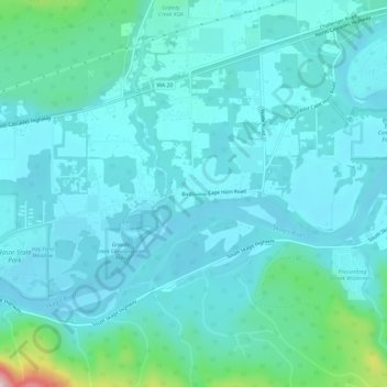
Nombre: Mapa topográfico Birdsview, altitud, relieve.
Lugar: Birdsview, Skagit County, Washington, United States (48.50233 -121.89542 48.54233 -121.85542)
Altitud media: 73 m
Altitud mínima: 29 m
Altitud máxima: 354 m
Otros mapas topográficos
Haga clic en un mapa para ver su topografía, su altitud y su relieve.
Skyline Home Owners Association
United States > Washington > Skagit County > Anacortes
Altitud media: 14 m
Concrete
United States > Washington > Skagit County
Mears Field (3W5), formerly known as Concrete Municipal Airport, is located one mile south of Concrete at an elevation of 267 ft MSL.
Altitud media: 125 m