
Mapa topográfico Southern Cross
Mapa interactivo
Haga clic en el mapa para ver la altitud.
Acerca de este mapa
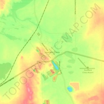
Nombre: Mapa topográfico Southern Cross, altitud, relieve.
Altitud media: 355 m
Altitud mínima: 310 m
Altitud máxima: 397 m
Otros mapas topográficos
Haga clic en un mapa para ver su topografía, su altitud y su relieve.
Boorabbin National Park
Australia > Western Australia > Southern Cross
Boorabbin National Park, Great Eastern Highway, Southern Cross, Western Australia, Australia
Altitud media: 426 m