
Mapa topográfico Ogden Dunes
Mapa interactivo
Haga clic en el mapa para ver la altitud.
Acerca de este mapa
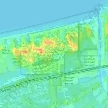
Nombre: Mapa topográfico Ogden Dunes, altitud, relieve.
Lugar: Ogden Dunes, Porter County, Indiana, United States (41.61433 -87.20288 41.63037 -87.18352)
Altitud media: 184 m
Altitud mínima: 175 m
Altitud máxima: 210 m
Otros mapas topográficos
Haga clic en un mapa para ver su topografía, su altitud y su relieve.
Valparaiso
United States > Indiana > Porter County
Valparaiso, Porter County, Indiana, United States
Altitud media: 235 m
Indiana Dunes State Park
United States > Indiana > Porter County > Chesterton
Indiana Dunes State Park, 1600, Chesterton, Porter County, Indiana, 46304, United States
Altitud media: 186 m
Portage
United States > Indiana > Porter County
Portage, Porter County, Indiana, United States
Altitud media: 190 m
Burns Harbor
United States > Indiana > Porter County
Burns Harbor, Porter County, Indiana, United States
Altitud media: 189 m
Indiana Dunes National Park
United States > Indiana > Porter County > Portage
Indiana Dunes National Park, Portage, Porter County, Indiana, 46403, United States
Altitud media: 188 m
Kouts
United States > Indiana > Porter County
Kouts, Porter County, Indiana, 46347, United States
Altitud media: 208 m
Chesterton
United States > Indiana > Porter County
Chesterton, Porter County, Indiana, 46304, United States
Altitud media: 200 m
Chesterton
United States > Indiana > Porter County > Chesterton
Chesterton, Porter County, Indiana, 46304, United States
Altitud media: 197 m
Beverly Shores
United States > Indiana > Porter County > Beverly Shores > Beverly Shores
Beverly Shores, Porter County, Indiana, 46301, United States
Altitud media: 182 m
Hebron
United States > Indiana > Porter County
Hebron, Porter County, Indiana, 46341, United States
Altitud media: 213 m