
Mapa topográfico Minden
Mapa interactivo
Haga clic en el mapa para ver la altitud.
Acerca de este mapa
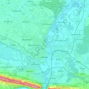
Nombre: Mapa topográfico Minden, altitud, relieve.
Lugar: Minden, Kreis Minden-Lübbecke, North Rhine-Westphalia, Germany (52.24706 8.79206 52.36487 8.99831)
Altitud media: 60 m
Altitud mínima: 34 m
Altitud máxima: 262 m
The lowest part of the town is in the district of Leteln, at 40 metres (131 feet), while the highest part is in the district of Haddenhausen at 181 metres (594 feet). The altitude of the town is given officially as 42.2 metres (138.5 feet), based on the elevation of the town hall.