
Mapa topográfico Decatur
Mapa interactivo
Haga clic en el mapa para ver la altitud.
Acerca de este mapa
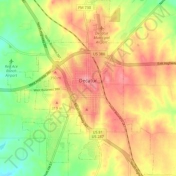
Nombre: Mapa topográfico Decatur, altitud, relieve.
Lugar: Decatur, Wise County, Texas, 76234, United States (33.19772 -97.62301 33.26524 -97.55589)
Altitud media: 297 m
Altitud mínima: 245 m
Altitud máxima: 340 m
According to the United States Census Bureau, the city has a total area of 8.5 square miles (22 km2), all land. The highest point of elevation in the county is the courthouse site. As with ancient hill towns in Europe, the frontier settlement was developed on high ground for defensive purposes, so European settlers could see and ward off attacks or raids, in this case by Native Americans.
Otros mapas topográficos
Haga clic en un mapa para ver su topografía, su altitud y su relieve.
Aurora
United States > Texas > Wise County
Aurora, Wise County, Texas, United States
Altitud media: 228 m
Rhome
United States > Texas > Wise County
Rhome, Wise County, Texas, 76078, United States
Altitud media: 259 m