
Mapa topográfico Village of Mamaroneck
Mapa interactivo
Haga clic en el mapa para ver la altitud.
Acerca de este mapa
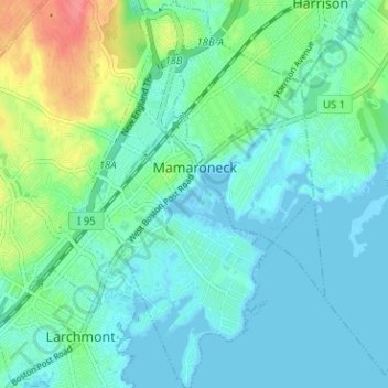
Nombre: Mapa topográfico Village of Mamaroneck, altitud, relieve.
Altitud media: 15 m
Altitud mínima: -3 m
Altitud máxima: 65 m
Other areas of the town include Heathcote Hill, overlooking the harbor, Harbor Heights (the heights) to the northeast, Old Rye Neck (settled in the 1880s), Rye Neck (settled in the 1920s and 1930s), Orienta, and Washingtonville, better known as "The Flats", due to the flat, low-lying topography of the area.
Otros mapas topográficos
Haga clic en un mapa para ver su topografía, su altitud y su relieve.
Village of Larchmont
United States > New York > Westchester County > Town of Mamaroneck
Village of Larchmont, Town of Mamaroneck, Westchester County, New York, 10538, United States
Altitud media: 8 m