
Mapa topográfico Sarawak
Mapa interactivo
Haga clic en el mapa para ver la altitud.
Acerca de este mapa
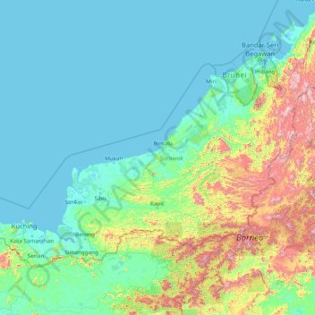
Nombre: Mapa topográfico Sarawak, altitud, relieve.
Lugar: Sarawak, Malaysia (0.85382 109.53804 5.10833 115.67803)
Altitud media: 228 m
Altitud mínima: -4 m
Altitud máxima: 2.148 m
Sarawak can be divided into two geological zones: the Sunda Shield, which extends southwest from the Batang Lupar River (near Sri Aman) and forms the southern tip of Sarawak, and the geosyncline region, which extends northeast to the Batang Lupar River, forming the central and northern regions of Sarawak. The oldest rock type in southern Sarawak is schist formed during the Carboniferous and Lower Permian times, while the youngest igneous rock in this region, andesite, can be found at Sematan. Geological formation of the central and northern regions started during the late Cretaceous period. Other types of stone that can be found in central and northern Sarawak are shale, sandstone, and chert. The Miri Division in eastern Sarawak is the region of Neogene strata containing organic rich rock formations which are the prolific oil and gas reserves. The rocks enriched in organic components are mudstones in Lambir, Miri and Tukau Formations of Middle Miocene-Lower Pliocene age. Significant quantities of Sarawak soil are lithosols, up to 60 per cent, and podsols, around 12 per cent, while abundant alluvial soil is found in coastal and riverine regions. 12 per cent of Sarawak is covered with peat swamp forest. Limestone with well-developed karst topography and cave systems is found scattered from west to east Sarawak, but concentrated in certain regions such as in the Bau district in the west and southwards near the Kalimantan border.
Otros mapas topográficos
Haga clic en un mapa para ver su topografía, su altitud y su relieve.
Johor Bahru
Johor Bahru, Iskandar Malaysia, Johor, 80350, Malaysia
Altitud media: 28 m
Kampung Tanjung Pari
Kampung Tanjung Pari, Baling, Kedah, Malaysia
Altitud media: 220 m
Genting Highlands
Genting Highlands, Bentong, Pahang, 69000, Malaysia
Altitud media: 1.141 m
Puchong
Malaysia > Selangor > Subang Jaya
Puchong, Subang Jaya, Petaling, Selangor, 47160, Malaysia
Altitud media: 38 m
Taman Rekreasi Kuala Kangsar
Malaysia > Perak > Kuala Kangsar
Taman Rekreasi Kuala Kangsar, Taman Sultan Yusuf, Bukit Chandan, Kuala Kangsar, Perak, Malaysia
Altitud media: 43 m
Kampung Seberang Guai
Kampung Seberang Guai, Bera, Pahang, Malaysia
Altitud media: 34 m
Tasik @ 7/1F
Malaysia > Selangor > Shah Alam
Tasik @ 7/1F, Section 7, Shah Alam, Petaling, Selangor, Malaysia
Altitud media: 24 m
Kampung Padang Serai
Malaysia > Kedah > Pokok Sena
Kampung Padang Serai, Pokok Sena, Kedah, 06400, Malaysia
Altitud media: 23 m
PJU 8
Malaysia > Selangor > Petaling Jaya
PJU 8, Petaling Jaya, Petaling, Selangor, Malaysia
Altitud media: 103 m
Semenyih
Malaysia > Kajang Municipal Council
Semenyih, Kajang Municipal Council, Hulu Langat, Selangor, 43500, Malaysia
Altitud media: 62 m
Sarawak River
Sarawak River, Kuching, Kuching Division, Sarawak, 93XXX, Malaysia
Altitud media: 6 m
Kajang Municipal Council
Kajang Municipal Council, Hulu Langat, Selangor, Malaysia
Altitud media: 198 m
Kampung Air Merah
Kampung Air Merah, Mersing, Johor, 86800, Malaysia
Altitud media: 10 m
Subang Jaya
Malaysia > Selangor > Subang Jaya
Subang Jaya, Selangor, 47610, Malaysia
Altitud media: 35 m
Kampung Anjung Batu
Kampung Anjung Batu, Tangkak, Johor, 84900, Malaysia
Altitud media: 16 m
Kampung Lui Muda
Kampung Lui Muda, Jempol, Negeri Sembilan, Malaysia
Altitud media: 118 m
Kampung Ulu Bendul
Kampung Ulu Bendul, Kuala Pilah, Negeri Sembilan, Malaysia
Altitud media: 326 m
Bukit Terbakar
Malaysia > Malacca > Alor Gajah
Bukit Terbakar, Alor Gajah, Malacca, 76000, Malaysia
Altitud media: 56 m
Kampung Sungai Balak
Malaysia > Selangor > Kajang Municipal Council
Kampung Sungai Balak, Kajang Municipal Council, Hulu Langat, Selangor, Malaysia
Altitud media: 38 m
Bukit Banang
Malaysia > Johor > Batu Pahat
Bukit Banang, Batu Pahat, Johor, 83000, Malaysia
Altitud media: 155 m