
Mapa topográfico Mill Brook
Mapa interactivo
Haga clic en el mapa para ver la altitud.
Acerca de este mapa
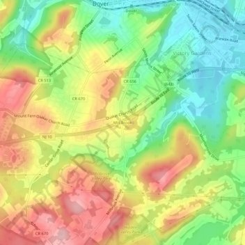
Nombre: Mapa topográfico Mill Brook, altitud, relieve.
Altitud media: 241 m
Altitud mínima: 166 m
Altitud máxima: 324 m
Otros mapas topográficos
Haga clic en un mapa para ver su topografía, su altitud y su relieve.
Shongum Lake Dam
United States > New Jersey > Morris County > Randolph Township
Shongum Lake Dam, Randolph Township, Morris County, New Jersey, 07869, United States
Altitud media: 255 m
Lake Cherokee
United States > New Jersey > Morris County > Randolph Township > Calais Crossroads
Lake Cherokee, Calais Crossroads, Randolph Township, Morris County, New Jersey, United States
Altitud media: 295 m
Ironia
United States > New Jersey > Morris County > Randolph Township
Ironia, Randolph Township, Morris County, New Jersey, 07876, United States
Altitud media: 260 m
Coleman Hollow
United States > New Jersey > Morris County > Randolph Township > Coleman Hollow
Coleman Hollow, Randolph Township, Morris County, New Jersey, 07845, United States
Altitud media: 263 m