
Mapa topográfico East Greenville
Mapa interactivo
Haga clic en el mapa para ver la altitud.
Acerca de este mapa
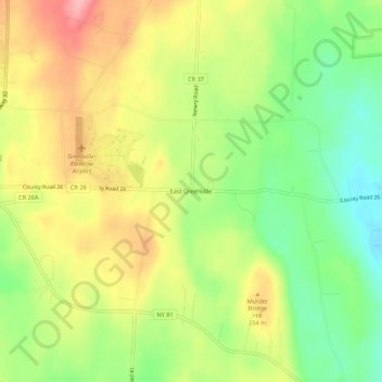
Nombre: Mapa topográfico East Greenville, altitud, relieve.
Altitud media: 227 m
Altitud mínima: 169 m
Altitud máxima: 290 m
Otros mapas topográficos
Haga clic en un mapa para ver su topografía, su altitud y su relieve.
Freehold
United States > New York > Greene County > Town of Greenville
Freehold, Town of Greenville, Greene County, New York, 12431, United States
Altitud media: 162 m
Greenville Center
United States > New York > Greene County > Town of Greenville
Greenville Center, Town of Greenville, Greene County, New York, 12176, United States
Altitud media: 228 m
West Greenville
United States > New York > Greene County > Town of Greenville
West Greenville, Town of Greenville, Greene County, New York, 12083, United States
Altitud media: 232 m
Newrys
United States > New York > Greene County > Town of Greenville
Newrys, Town of Greenville, Greene County, New York, 12083, United States
Altitud media: 255 m
Surprise
United States > New York > Greene County > Town of Greenville
Surprise, Town of Greenville, Greene County, New York, 12176, United States
Altitud media: 192 m
Norton Hill
United States > New York > Greene County > Town of Greenville
Norton Hill, Town of Greenville, Greene County, New York, 12083, United States
Altitud media: 259 m
Place Corners
United States > New York > Greene County > Town of Greenville
Place Corners, Town of Greenville, Greene County, New York, 12431, United States
Altitud media: 217 m