
Mapa topográfico Krasnoyarsk
Mapa interactivo
Haga clic en el mapa para ver la altitud.
Acerca de este mapa
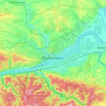
Nombre: Mapa topográfico Krasnoyarsk, altitud, relieve.
Altitud media: 285 m
Altitud mínima: 118 m
Altitud máxima: 792 m
The river Yenisei flows from west to east through the city. Due to the Krasnoyarsk hydroelectric dam 32 km (20 mi) upstream, the Yenisei never freezes in winter and never exceeds +14 °C (57 °F) in summer through the city. Near the city center, its elevation is 136 m (446 ft) above sea level. There are several islands in the river, the largest of which are Tatyshev and Otdyha Isles, used mainly for recreation.