
Mapa topográfico Lorneville
Mapa interactivo
Haga clic en el mapa para ver la altitud.
Acerca de este mapa
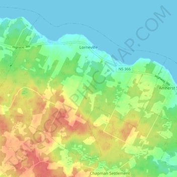
Nombre: Mapa topográfico Lorneville, altitud, relieve.
Altitud media: 20 m
Altitud mínima: -1 m
Altitud máxima: 52 m
Otros mapas topográficos
Haga clic en un mapa para ver su topografía, su altitud y su relieve.
Nappan
Canada > Nova Scotia > Municipality of the County of Cumberland
Nappan, Municipality of the County of Cumberland, Cumberland County, Nova Scotia, B0L 1C0, Canada
Altitud media: 25 m
Rockley
Canada > Nova Scotia > Municipality of the County of Cumberland
Rockley, Municipality of the County of Cumberland, Cumberland County, Nova Scotia, B0M 1V0, Canada
Altitud media: 24 m
Wentworth Provincial Park
Canada > Nova Scotia > Municipality of the County of Cumberland > Wentworth Station
Wentworth Provincial Park, Valley Road, Wentworth Station, Wentworth, Municipality of the County of Cumberland, Cumberland County, Nova Scotia, B0M 1Z0, Canada
Altitud media: 81 m
Isle Haute
Canada > Nova Scotia > Municipality of the County of Cumberland
Isle Haute, Municipality of the County of Cumberland, Cumberland County, Nova Scotia, Canada
Altitud media: 1 m
Roslin
Canada > Nova Scotia > Municipality of the County of Cumberland
Roslin, Municipality of the County of Cumberland, Cumberland County, Nova Scotia, B0M 1P0, Canada
Altitud media: 34 m
Fenwick
Canada > Nova Scotia > Municipality of the County of Cumberland
Fenwick, Municipality of the County of Cumberland, Cumberland County, Nova Scotia, B0L 1C0, Canada
Altitud media: 79 m