
Gracias por apoyar a este sitio ❤️
Haz una donación
Haz una donación
Mapa topográfico Rubihorn
Haga clic en el mapa para ver la altitud.
Gracias por apoyar a este sitio ❤️
Haz una donación
Haz una donación
Acerca de este mapa
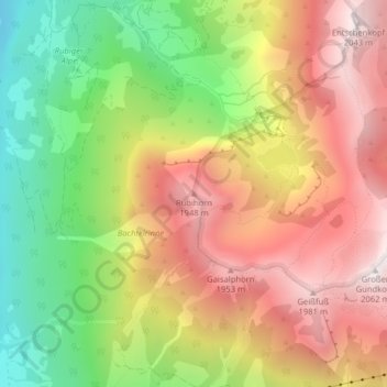
Nombre: Mapa topográfico Rubihorn, altitud, relieve.
Altitud media: 1.467 m
Altitud mínima: 858 m
Altitud máxima: 2.034 m
Gracias por apoyar a este sitio ❤️
Haz una donación
Haz una donación
Otros mapas topográficos
Haga clic en un mapa para ver su topografía, su altitud y su relieve.
Schlappolt
Deutschland > Bayern > Landkreis Oberallgäu > Oberstdorf
Das 163,43 ha große Gebiet mit der Nr. NSG-00298.01 wurde im Jahr 1986 unter Naturschutz gestellt. Es ist in Bayern der einzige Flyschbereich, der nahezu die alpine Höhenstufe erreicht.
Altitud media: 1.587 m