
Gracias por apoyar a este sitio ❤️
Haz una donación
Haz una donación
Mapa topográfico Queenborough
Haga clic en el mapa para ver la altitud.
Gracias por apoyar a este sitio ❤️
Haz una donación
Haz una donación
Acerca de este mapa
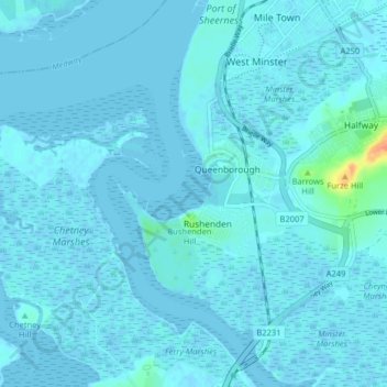
Nombre: Mapa topográfico Queenborough, altitud, relieve.
Lugar: Queenborough, Borough of Swale, Kent, England, United Kingdom (51.39019 0.69194 51.43479 0.77219)
Altitud media: 2 m
Altitud mínima: -4 m
Altitud máxima: 40 m
Gracias por apoyar a este sitio ❤️
Haz una donación
Haz una donación
Otros mapas topográficos
Haga clic en un mapa para ver su topografía, su altitud y su relieve.
Gracias por apoyar a este sitio ❤️
Haz una donación
Haz una donación
Gracias por apoyar a este sitio ❤️
Haz una donación
Haz una donación
Faversham Creek
United Kingdom > England > Kent > Borough of Swale > Faversham > Oare
Altitud media: 11 m
Gracias por apoyar a este sitio ❤️
Haz una donación
Haz una donación
Hickmans Green
United Kingdom > England > Kent > Borough of Swale > Boughton Street
Altitud media: 63 m
Gracias por apoyar a este sitio ❤️
Haz una donación
Haz una donación
Gracias por apoyar a este sitio ❤️
Haz una donación
Haz una donación
Faversham Creek
United Kingdom > England > Kent > Borough of Swale > Faversham > Oare
Altitud media: 8 m
Gracias por apoyar a este sitio ❤️
Haz una donación
Haz una donación
Rodmersham Green
United Kingdom > England > Kent > Borough of Swale > Rodmersham Green
Altitud media: 48 m
Gracias por apoyar a este sitio ❤️
Haz una donación
Haz una donación
Gracias por apoyar a este sitio ❤️
Haz una donación
Haz una donación