
Mapa topográfico Les Guesdons
Mapa interactivo
Haga clic en el mapa para ver la altitud.
Acerca de este mapa
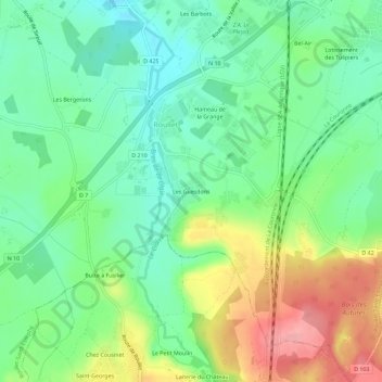
Nombre: Mapa topográfico Les Guesdons, altitud, relieve.
Altitud media: 72 m
Altitud mínima: 32 m
Altitud máxima: 142 m
Otros mapas topográficos
Haga clic en un mapa para ver su topografía, su altitud y su relieve.
Hameau de la Grange
France > Nouvelle-Aquitaine > Charente > Roullet-Saint-Estèphe > Roullet
Hameau de la Grange, Roullet, Roullet-Saint-Estèphe, Angoulême, Charente, Nouvelle-Aquitaine, France métropolitaine, 16440, France
Altitud media: 63 m