
Mapa topográfico The West Lion
Mapa interactivo
Haga clic en el mapa para ver la altitud.
Acerca de este mapa
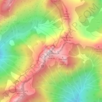
Nombre: Mapa topográfico The West Lion, altitud, relieve.
Altitud media: 1.159 m
Altitud mínima: 724 m
Altitud máxima: 1.585 m
Hikers can climb up to the ridge between the East and West Lion peaks using either the Binkert Trail leading up from Lions Bay, or the Howe Sound Crest Trail. The Binkert Trail, named after Paul Binkert of the British Columbia Mountaineering Club, is one of the most popular in the Lower Mainland. Hiking to the ridge from Lions Bay takes approximately four hours and gains 1,280 m (4,199 ft) in elevation. Most hikers stop there as both the East and West Lion peaks require rock climbing equipment and expertise. The East Lion is out-of-bounds for climbing as it is located in the Greater Vancouver watershed.
Otros mapas topográficos
Haga clic en un mapa para ver su topografía, su altitud y su relieve.
Metro Vancouver Regional Parks
Canada > British Columbia > Metro Vancouver Regional District > Electoral Area A
Metro Vancouver Regional Parks, Electoral Area A, District of North Vancouver, Metro Vancouver Regional District, British Columbia, Canada
Altitud media: 191 m