
Mapa topográfico Momberg
Mapa interactivo
Haga clic en el mapa para ver la altitud.
Acerca de este mapa
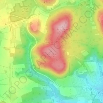
Nombre: Mapa topográfico Momberg, altitud, relieve.
Altitud media: 410 m
Altitud mínima: 323 m
Altitud máxima: 512 m
Otros mapas topográficos
Haga clic en un mapa para ver su topografía, su altitud y su relieve.
Oberthal
Deutschland > Saarland > Oberthal
Oberthal, Landkreis St. Wendel, Saarland, 66649, Deutschland
Altitud media: 377 m
Güdesweiler
Deutschland > Saarland > Oberthal
Güdesweiler, Oberthal, Landkreis St. Wendel, Saarland, Deutschland
Altitud media: 380 m