
Mapa topográfico Fayetteville
Mapa interactivo
Haga clic en el mapa para ver la altitud.
Acerca de este mapa
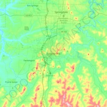
Nombre: Mapa topográfico Fayetteville, altitud, relieve.
Altitud media: 404 m
Altitud mínima: 310 m
Altitud máxima: 674 m
...yet I venture the assertion that nowhere in said country—or for that matter, in any part of the state—could be found a lovelier elevation, or a lovelier grove of graceful oaks, or a more commanding view, or, in fine, a spot better suited and adapted for the purposes designated than the one chosen for said University site and farm.
Otros mapas topográficos
Haga clic en un mapa para ver su topografía, su altitud y su relieve.
South Mountain
United States > Arkansas > Washington County > Fayetteville
South Mountain, Fayetteville, Washington County, Arkansas, 72701, United States
Altitud media: 405 m
Washington Mountain
United States > Arkansas > Washington County > Fayetteville
Washington Mountain, Fayetteville, Washington County, Arkansas, United States
Altitud media: 409 m