
Mapa topográfico Ledgewood
Mapa interactivo
Haga clic en el mapa para ver la altitud.
Acerca de este mapa
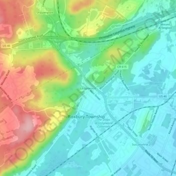
Nombre: Mapa topográfico Ledgewood, altitud, relieve.
Altitud media: 265 m
Altitud mínima: 214 m
Altitud máxima: 369 m
Otros mapas topográficos
Haga clic en un mapa para ver su topografía, su altitud y su relieve.
Kenvil
United States > New Jersey > Morris County > Roxbury Township
Kenvil, Roxbury Township, Morris County, New Jersey, 07847, United States
Altitud media: 239 m
Succasunna
United States > New Jersey > Morris County > Roxbury Township
Succasunna, Roxbury Township, Morris County, New Jersey, 07847, United States
Altitud media: 232 m
Landing
United States > New Jersey > Morris County > Roxbury Township
Landing, Roxbury Township, Morris County, New Jersey, 07850, United States
Altitud media: 297 m