
Gracias por apoyar a este sitio ❤️
Haz una donación
Haz una donación
Mapa topográfico Kastenfeld
Haga clic en el mapa para ver la altitud.
Gracias por apoyar a este sitio ❤️
Haz una donación
Haz una donación
Acerca de este mapa
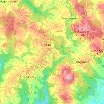
Nombre: Mapa topográfico Kastenfeld, altitud, relieve.
Altitud media: 416 m
Altitud mínima: 332 m
Altitud máxima: 489 m
Gracias por apoyar a este sitio ❤️
Haz una donación
Haz una donación
Otros mapas topográficos
Haga clic en un mapa para ver su topografía, su altitud y su relieve.
94360
Deutschland > Bayern > Landkreis Straubing-Bogen > Scheibelsgrub > Talmühle
Altitud media: 399 m