
Mapa topográfico Sheyenne River
Mapa interactivo
Haga clic en el mapa para ver la altitud.
Acerca de este mapa
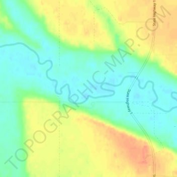
Nombre: Mapa topográfico Sheyenne River, altitud, relieve.
Lugar: Sheyenne River, Nelson County, North Dakota, 58361, USA (47.75908 -98.33601 47.76359 -98.31680)
Altitud media: 428 m
Altitud mínima: 409 m
Altitud máxima: 450 m
Otros mapas topográficos
Haga clic en un mapa para ver su topografía, su altitud y su relieve.
Lake Sakakawea
Lake Sakakawea, McLean County, North Dakota, USA
Altitud media: 651 m
Theodore Roosevelt National Park
Theodore Roosevelt National Park, Billings County, North Dakota, USA
Altitud media: 684 m
Lake Ashtabula
Lake Ashtabula, 15th Street Southeast, Barnes County, North Dakota, 58056, USA
Altitud media: 423 m
Lake Tschida
Lake Tschida, 56th Street Southwest, Grant County, North Dakota, USA
Altitud media: 661 m
Rock Lake
USA > North Dakota > Rock Lake
Rock Lake, Towner County, North Dakota, USA
Altitud media: 472 m
General Sibley Park & Campground
General Sibley Park & Campground, Burleigh County, North Dakota, USA
Altitud media: 498 m
Lake Metigoshe State Park
Lake Metigoshe State Park, Bottineau County, North Dakota, USA
Altitud media: 660 m
Boundary Lake
Boundary Lake, 23rd Avenue Northeast, Bottineau County, North Dakota, USA
Altitud media: 685 m
Dunseith
USA > North Dakota > Dunseith
Dunseith, Rolette County, North Dakota, USA
Altitud media: 521 m