
Mapa topográfico Gransha
Mapa interactivo
Haga clic en el mapa para ver la altitud.
Acerca de este mapa
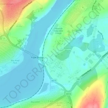
Nombre: Mapa topográfico Gransha, altitud, relieve.
Altitud media: 22 m
Altitud mínima: -2 m
Altitud máxima: 83 m
Otros mapas topográficos
Haga clic en un mapa para ver su topografía, su altitud y su relieve.
Altnagelvin
United Kingdom > Northern Ireland > Londonderry/Derry
Altnagelvin, Londonderry/Derry, County Londonderry, Northern Ireland, United Kingdom
Altitud media: 67 m
Clooney
United Kingdom > Northern Ireland > Londonderry/Derry
Clooney, Londonderry/Derry, County Londonderry, Northern Ireland, United Kingdom
Altitud media: 39 m
Glack
United Kingdom > Northern Ireland > Londonderry/Derry
Glack, Londonderry/Derry, County Londonderry, Northern Ireland, United Kingdom
Altitud media: 201 m
Coshquin
United Kingdom > Northern Ireland > Londonderry/Derry
Coshquin, Londonderry/Derry, County Londonderry, Northern Ireland, United Kingdom
Altitud media: 91 m
Binevenagh
United Kingdom > Northern Ireland > Londonderry/Derry
Binevenagh, Londonderry/Derry, County Londonderry, Northern Ireland, BT49 0JB, United Kingdom
Altitud media: 246 m