
Gracias por apoyar a este sitio ❤️
Haz una donación
Haz una donación
Mapa topográfico Bredgar
Haga clic en el mapa para ver la altitud.
Gracias por apoyar a este sitio ❤️
Haz una donación
Haz una donación
Acerca de este mapa
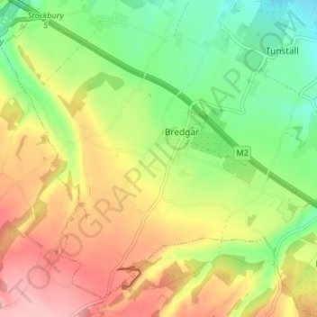
Nombre: Mapa topográfico Bredgar, altitud, relieve.
Lugar: Bredgar, Borough of Swale, Kent, England, United Kingdom (51.29118 0.65877 51.32770 0.72482)
Altitud media: 100 m
Altitud mínima: 39 m
Altitud máxima: 168 m
Gracias por apoyar a este sitio ❤️
Haz una donación
Haz una donación
Otros mapas topográficos
Haga clic en un mapa para ver su topografía, su altitud y su relieve.
Gracias por apoyar a este sitio ❤️
Haz una donación
Haz una donación
Gracias por apoyar a este sitio ❤️
Haz una donación
Haz una donación
Faversham Creek
United Kingdom > England > Kent > Borough of Swale > Faversham > Oare
Altitud media: 11 m
Gracias por apoyar a este sitio ❤️
Haz una donación
Haz una donación
Hickmans Green
United Kingdom > England > Kent > Borough of Swale > Boughton Street
Altitud media: 63 m
Gracias por apoyar a este sitio ❤️
Haz una donación
Haz una donación
Gracias por apoyar a este sitio ❤️
Haz una donación
Haz una donación
Faversham Creek
United Kingdom > England > Kent > Borough of Swale > Faversham > Oare
Altitud media: 8 m
Gracias por apoyar a este sitio ❤️
Haz una donación
Haz una donación
Rodmersham Green
United Kingdom > England > Kent > Borough of Swale > Rodmersham Green
Altitud media: 48 m
Gracias por apoyar a este sitio ❤️
Haz una donación
Haz una donación
Gracias por apoyar a este sitio ❤️
Haz una donación
Haz una donación