
Mapa topográfico Karaikudi
Mapa interactivo
Haga clic en el mapa para ver la altitud.
Acerca de este mapa
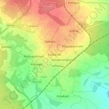
Nombre: Mapa topográfico Karaikudi, altitud, relieve.
Altitud media: 87 m
Altitud mínima: 55 m
Altitud máxima: 118 m
Karaikudi is located in Sivagangai district of Tamil Nadu State. The Trichy–Rameswaram Highway passes through Karaikudi. The Thennar River flows through South Karaikudi. Karaikudi is located at 10°04′N 78°47′E / 10.07°N 78.78°E / 10.07; 78.78. It has an average elevation of 82 metres (269 ft). The terrain of Karaikudi is predominantly flat. Rocky areas are found in the surrounding areas of Karaikudi town with more rocks towards the western side of the town. The soil is of the hard red lateritic type and is not suitable for cultivation. The water table in the area is generally at depths of 3 to 6 ft (0.91 to 1.83 m) and rises to nearly 1 m (3 ft 3 in) below the ground level during rainy seasons. Since the 1970s, the water supply of the Karaikudi residents has depended on the deeper aquifers. The average maximum temperature is about 34 °C (93 °F), and average minimum temperature is about 24 °C (75 °F). The annual average rainfall in Karaikudi is about 920 millimetres (36 inches).
Otros mapas topográficos
Haga clic en un mapa para ver su topografía, su altitud y su relieve.
Pallathur
India > Tamil Nadu > Karaikkudi
Pallathur, Karaikkudi, Sivagangai District, Tamil Nadu, 630107, India
Altitud media: 98 m