
Mapa topográfico Suez Canal
Mapa interactivo
Haga clic en el mapa para ver la altitud.
Acerca de este mapa
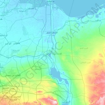
Nombre: Mapa topográfico Suez Canal, altitud, relieve.
Lugar: Suez Canal, Port Said, 43522, Egypt (29.93034 32.30378 31.27571 32.58750)
Altitud media: 106 m
Altitud mínima: -6 m
Altitud máxima: 869 m
Although the alleged difference in sea levels could be problematic for construction, the idea of finding a shorter route to the east remained alive. In 1830, F. R. Chesney submitted a report to the British government that stated that there was no difference in elevation and that the Suez Canal was feasible, but his report received no further attention. Lieutenant Waghorn established his "Overland Route", which transported post and passengers to India via Egypt.
Otros mapas topográficos
Haga clic en un mapa para ver su topografía, su altitud y su relieve.
Al-ʿAbbāsiyyah Canal
Al-ʿAbbāsiyyah Canal, Port Said, 41524, Egypt
Altitud media: 16 m