
Haz una donación
Mapa topográfico Bangladesh
Haga clic en el mapa para ver la altitud.
Haz una donación
Bangladesh
With an elevation of 1,064 m (3,491 ft), Saka Haphong (also known as Mowdok Mual) near the border with Myanmar, is claimed to be the highest peak of Bangladesh. However, it is not yet widely recognized as the highest point of the country, and most sources give the honor to Keokradong.
Haz una donación
Acerca de este mapa
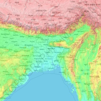
Nombre: Mapa topográfico Bangladesh, altitud, relieve.
Lugar: Bangladesh (17.47688 83.29324 31.47688 97.29324)
Altitud media: 1.488 m
Altitud mínima: -3 m
Altitud máxima: 7.813 m
Haz una donación
Otros mapas topográficos
Haga clic en un mapa para ver su topografía, su altitud y su relieve.
Sylhet Division
The region is considered one of the most picturesque and archaeologically rich regions in South Asia. It is home to three national parks; the Lawachara National Park, Khadim Nagar National Park and Satchari National Park, as well as numerous smaller parks and forests such as the Ratargul Swamp Forest,…
Altitud media: 88 m
Rajeshpur Eco-Park
Bangladesh > Chattogram Division > Cumilla Adarsha Sadar Upazila
Altitud media: 15 m
Haz una donación