
Mapa topográfico Tres Cantos
Mapa interactivo
Haga clic en el mapa para ver la altitud.
Acerca de este mapa
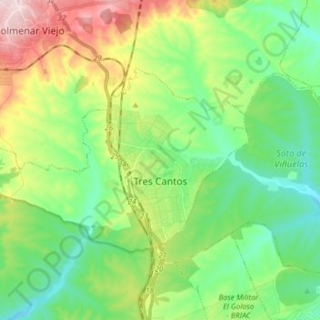
Nombre: Mapa topográfico Tres Cantos, altitud, relieve.
Altitud media: 720 m
Altitud mínima: 627 m
Altitud máxima: 913 m
Tres Cantos was built on former rural lands, about halfway from the northern outskirts of suburban Madrid to the Guadarrama mountain range, which are frequently snow-capped in winter. It lies in a slight valley formed with two eastwards-flowing creeks, bounded to the south by a higher plateau leading to Madrid, and to the west and north by more hilly terrain, which separates the area from the watershed of the Manzanares River. General elevation of the township is around 680 m, with a highest elevation within the municipality's borders of 730 m. The terrain rises towards the foothills of the Guadarrama range to the north and northwest, reaching elevations in excess of 800 m across the border in Colmenar Viejo. Within the urban area the terrain is gently undulating. It also an enormous new phase where there has been construction of new houses for new people for a long time. This new part of Tres Cantos is going to be named the Third Phase and is only composed of modern buildings and new houses for the city to expand.