
Haz una donación
Mapa topográfico Omak
Haga clic en el mapa para ver la altitud.
Haz una donación
Omak
Elevations around the area range from 780 feet (240 m) above sea level at the mouth of the Okanogan River to 6,774 feet (2,065 m) above sea level at the Moses Mountain. The average elevation is 843 feet (257 m) above sea level according to the United States Geological Survey (USGS). The Moses Mountain, with a summit, sits east of the city, while Little Moses Mountain, located 5,963 feet (1,818 m) above sea level, and Omak Mountain, located 5,749 feet (1,752 m) above sea level, are adjacent to the Moses Mountain. West of the city are the North Cascades, anchored by the Cascade Range. Mountain peaks on the western portion of the Omak area range between 6,000 feet (1,800 m) and 8,000 feet (2,400 m). The Coleman Butte mountain summit—1,450 feet (440 m) above sea level—is located directly adjacent to municipal boundaries.
Haz una donación
Acerca de este mapa
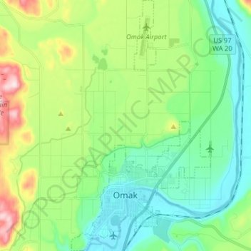
Nombre: Mapa topográfico Omak, altitud, relieve.
Lugar: Omak, Okanogan County, Washington, 98841, United States (48.39207 -119.55500 48.47666 -119.48419)
Altitud media: 364 m
Altitud mínima: 249 m
Altitud máxima: 658 m
Haz una donación
Otros mapas topográficos
Haga clic en un mapa para ver su topografía, su altitud y su relieve.
Haz una donación
Haz una donación
Haz una donación
Haz una donación