
Mapa topográfico Acme
Haga clic en el mapa para ver la altitud.
Acerca de este mapa
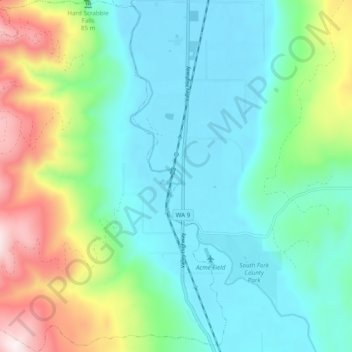
Nombre: Mapa topográfico Acme, altitud, relieve.
Lugar: Acme, Whatcom County, Washington, 98220, United States (48.69669 -122.26817 48.76051 -122.19134)
Altitud media: 420 m
Altitud mínima: 74 m
Altitud máxima: 937 m
Otros mapas topográficos
Haga clic en un mapa para ver su topografía, su altitud y su relieve.
Tomyhoi Peak
United States > Washington > Whatcom County
The nearest higher peak is Canadian Border Peak, 2.4 miles (3.9 km) to the northeast. Precipitation runoff on the east side of Tomyhoi Peak drains into Tomyhoi Lake and Tomyhoi Creek, whereas the west side of the mountain drains into Damfino Creek, all eventually reaching the Chilliwack River in Canada.…
Altitud media: 1.580 m
Mount Redoubt
United States > Washington > Whatcom County
The North Cascades features some of the most rugged topography in the Cascade Range with craggy peaks, spires, ridges, and deep glacial valleys. Geological events occurring many years ago created the diverse topography and drastic elevation changes over the Cascade Range leading to the various climate…
Altitud media: 2.070 m
Ruby Mountain
United States > Washington > Whatcom County
Ruby Mountain is a prominent 7,412-foot (2,259-metre) mountain summit located in the North Cascades Range of Washington state. It is situated in Ross Lake National Recreation Area which is part of the North Cascades National Park Complex. The Diablo Lake Overlook along the North Cascades Highway is at the foot…
Altitud media: 1.731 m
Bellingham
United States > Washington > Whatcom County > Bellingham
According to the United States Census Bureau, the city has a total area of 28.90 square miles (74.85 km2), of which, 27.08 square miles (70.14 km2) is land and 1.82 square miles (4.71 km2) is water. The lowest elevations are at sea level along the waterfront. Alabama Hill is one of the higher points in the…
Altitud media: 129 m