
Mapa topográfico Distrito Ciudad de Luján de Cuyo
Mapa interactivo
Haga clic en el mapa para ver la altitud.
Acerca de este mapa
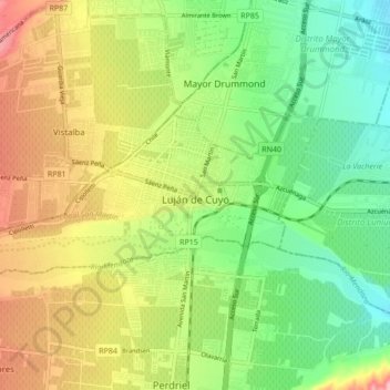
Nombre: Mapa topográfico Distrito Ciudad de Luján de Cuyo, altitud, relieve.
Altitud media: 949 m
Altitud mínima: 888 m
Altitud máxima: 1.033 m
Situated in the upper Mendoza valley, where the river is half-way through its journey from the Andes mountains to the eastern plains, many Lujan de Cuyo vineyards sit at altitudes of around 1000 m (3280 ft). Malbec in particular is successful in Lujan de Cuyo, but the appellation also produces good Cabernet Sauvignon, Chardonnay and Torrontes. The majority of the vineyards are on alluvial soils; sandy or stony surfaces on clay substrata.
Otros mapas topográficos
Haga clic en un mapa para ver su topografía, su altitud y su relieve.
Luján de Cuyo
Argentina > Mendoza > Departamento Luján de Cuyo > Luján de Cuyo
Luján de Cuyo, Distrito Chacras de Coria, Departamento Luján de Cuyo, Mendoza, Argentina
Altitud media: 943 m